33 Best Hikes For First-Timers in Yosemite National Park
If you are anything like me, you’re planning your first (or maybe second or third) trip to Yosemite and don’t want to miss anything, but you’re overwhelmed with the size of the park and trying to figure out which trails are actually worth your time.
Hiking is time consuming! These aren’t just roadside viewpoints where you can see them all – you have to pick and choose wisely based on how much time you have in the park.
So I’ve got you! I’ve been hiking in Yosemite for nearly 10 years, been in every season, and hiked hundreds of miles within the park. I’m going to guide you and tell you all of the best hikes – including a lot that aren’t even mentioned in the park newspaper (like the amazing Snow Creek Trail)!
In this guide I’m sharing hikes from every single part of the park (not just the Valley!), and for every experience level. So whether you’re completely new to hiking or looking for an all-day adventure, I’ve got you covered.
I’m going to share a ton of different hikes in this post, but I don’t want to bury the lead: my absolute favorite hikes that I think every Yosemite visitor must experience are: The Mist Trail, Taft Point, Lower Yosemite Falls, Cathedral Lakes, Cloud’s Rest, and North Dome (and yes, in that order too).
I think those are the best because they offer the most “bang for your buck” in terms of views, trail experience, and uniqueness.
Let’s go hiking!

Backcountry Emily contains affiliate links and I may receive compensation - at no extra cost to you! As an Amazon Associate I earn from qualifying purchases. See my Privacy Policy for more information.
Best Yosemite Valley Day Hikes
The hikes in Yosemite Valley are pretty much either super easy or super hard without a ton of middle ground. That’s because so many climb directly up the towering granite walls all around you!
I’ve listed the hikes in this section from easiest to hardest so you can find the ones that are best for you.
Another challenging hurdle in the Valley: parking. I’d recommend parking in the main Visitor Center parking or the trailhead parking by Curry Village and taking the free valley-wide shuttle to the trailheads!
There’s a lot of awesome hikes in the Valley, but if you can’t do them all: The Mist Trail and Lower Yosemite Falls are the ones you must do.
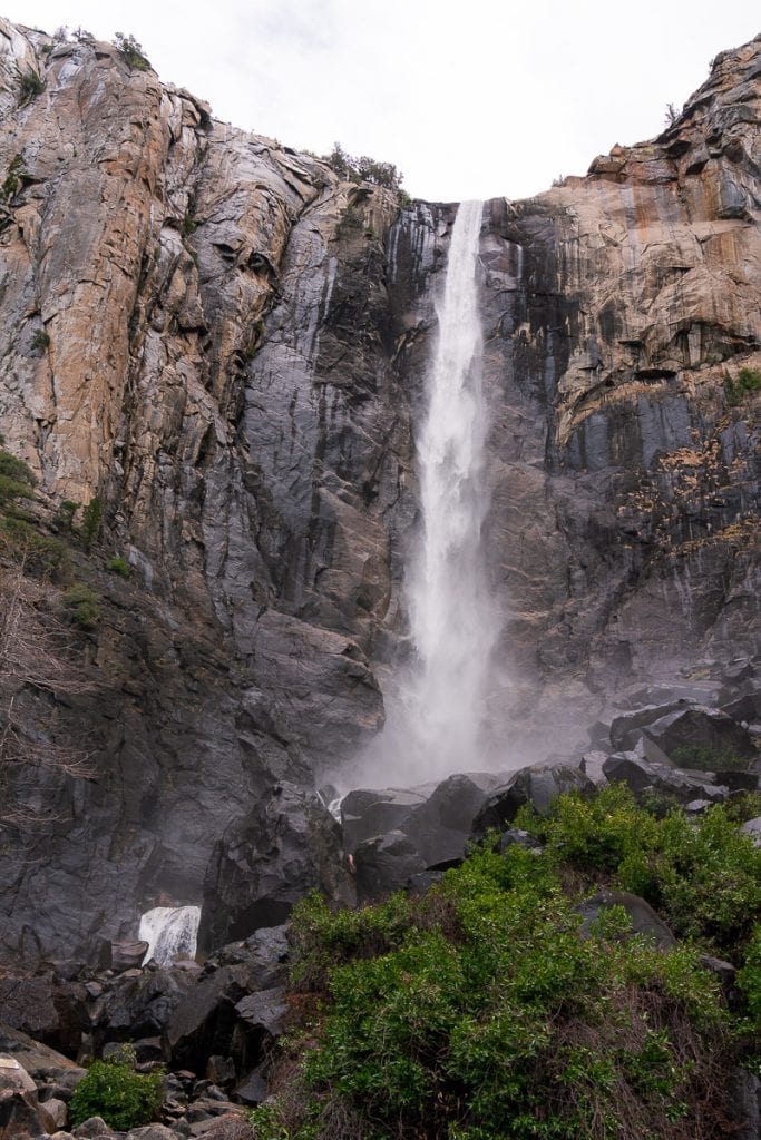
1. Bridalveil Fall
I love this short hike because it feels like you are standing directly under the waterfall at the viewing platform! It’s pretty cool to be looking straight up the waterfall and rock wall.
You can access this hike from 2 spots: the main parking lot, or along Southside drive. There’s lots of parking in both places, but it does get really crowded here since it’s the first feature people have access to when driving into the park.
Pro tip: Prepare to get wet! And stay alert on trail: the mist makes the tread pretty slippery.
Trail Info
- Distance: 0.5 mi
- Elevation Gain/ Loss: 80 feet
- Trail Type: Out & Back
- Difficulty: Easy
- Trailhead: Bridalveil Fall (not on the shuttle system)
- Scenery Rating: 3/5
- Check current conditions and download on AllTrails

2. Lower Yosemite Falls
This is also more of a walk than a hike, but it’s something that everyone visiting Yosemite should see because it’s simply iconic!
I recommend doing the full loop vs. just walking the paved portion to the lower falls since it’s a nice chance to get a little solitude on the valley floor.
The park service highly advises you to not approach the base of the falls as the rocks get super slippery from the mist and the river. There have been multiple deaths & injuries from this area because people underestimate this risk.
Pro tip: Go in the early morning or around dusk. It’s less crowded and you might even have the chance to see wildlife: I’ve gotten super lucky here and seen black bears and even a bobcat on separate visits!
Trail Info
- Distance: 1 mile
- Elevation Gain/ Loss: 50 feet
- Trail Type: Loop
- Difficulty: Easy
- Trailhead: Lower Yosemite Falls (shuttle stop #6)
- Scenery Rating: 4/5
- Check current conditions and download on AllTrails

3. Cooks Meadow Loop
I love this stroll because the views of Half Dome and Yosemite Falls are just out-of-this-world! This trail is partially paved and also has boardwalks over the sensitive meadow that floods.
I usually pair this walk with Lower Yosemite Falls or extend it to include the Sentinel or Superintendent’s bridges or the chapel. And sometimes I’ll walk the sidewalk to Yosemite Village to grab food at Degnan’s.
However you do it, it’s a great filler in between more intense activities or part of a larger valley floor walk!
Trail Info
- Distance: 1 mile
- Elevation Gain/ Loss: 0
- Trail Type: Loop
- Difficulty: Easy
- Trailhead: Lower Yosemite Falls (shuttle stop #6)
- Scenery Rating: 4/5
- Check current conditions and download on AllTrails

4. Mirror Lake
One of my favorite short hikes in the Valley! This is best done in the spring and early summer when Mirror Lake is actually present. It dries up later in the summer because it’s not actually a lake… it’s a widening of Tenaya Creek.
If you have the time to do the full loop around the lake, I definitely recommend it. Otherwise, just hike the paved road to the main reflection of Mt. Watkins and hike a little ways in on the left side of the lake to see Half Dome right above you! It’s a super cool perspective that you can’t find anywhere else in the park.
If you have a handicap placard for your car, you can drive the paved road to the lake, making this a great accessible destination. I did this with my grandparents and they loved being able to see this lake!
Trail Info
- Distance: 2 – 5 miles
- Elevation Gain/ Loss: 100 feet
- Trail Type: Out & Back or Loop
- Difficulty: Easy to Moderate
- Trailhead: Mirror Lake Trailhead (shuttle stop #17)
- Scenery Rating: 4/5
- Check current conditions and download on AllTrails
5. Yosemite Valley Loop
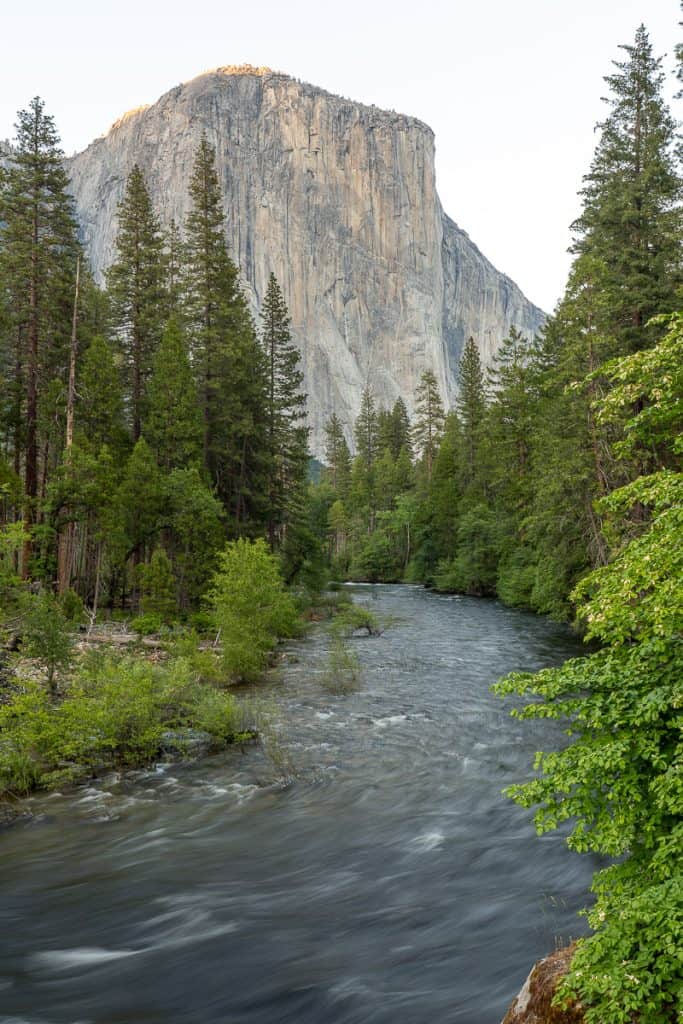
I still haven’t hiked the full Valley floor loop, but I have hiked portions of it. I love this trail because it gets you away from the crowds and gives you completely new perspectives of famous sights like El Capitan, the Cathedral Rocks, and more!
It’s also one of the best trails to hike in Yosemite in the fall – you get to walk around all the deciduous trees in the Valley, and it just feels really magical!
The stats I’ve listed below are for the western part of the loop, west of the visitor center/ village area. I think this part has the best sections of trail: the eastern part is more tucked away under tree cover and shares more paved path with cyclists than I like.
Trail Info
- Distance: 11.5 miles
- Elevation Gain/ Loss: 580 feet
- Trail Type: Loop
- Difficulty: Moderate
- Trailhead: Multiple – Lower Yosemite Falls, Camp 4, Swinging Bridge Picnic Area, Cathedral Beach Picnic Area
- Scenery Rating: 4/5
- Check current conditions and download on AllTrails

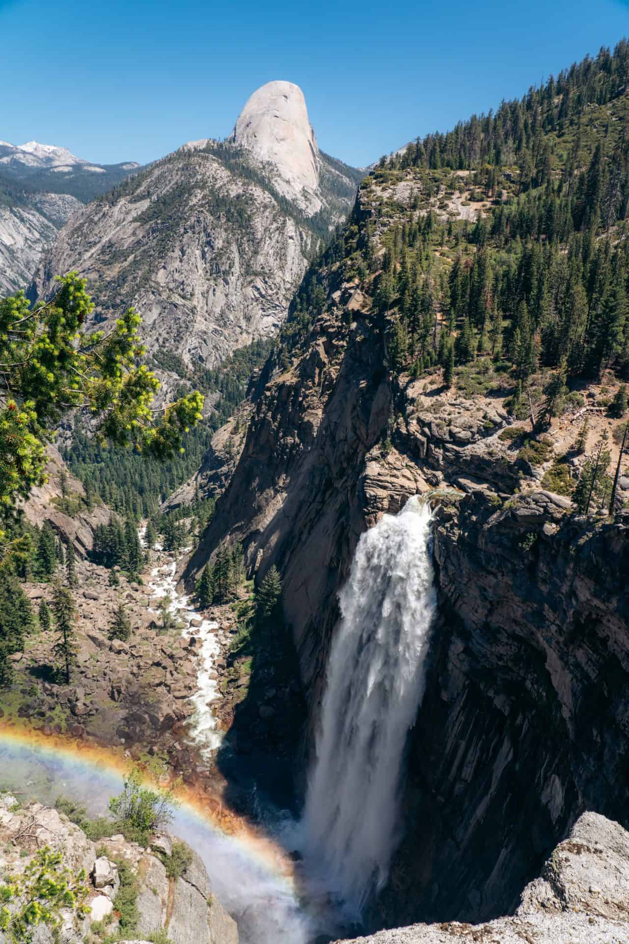
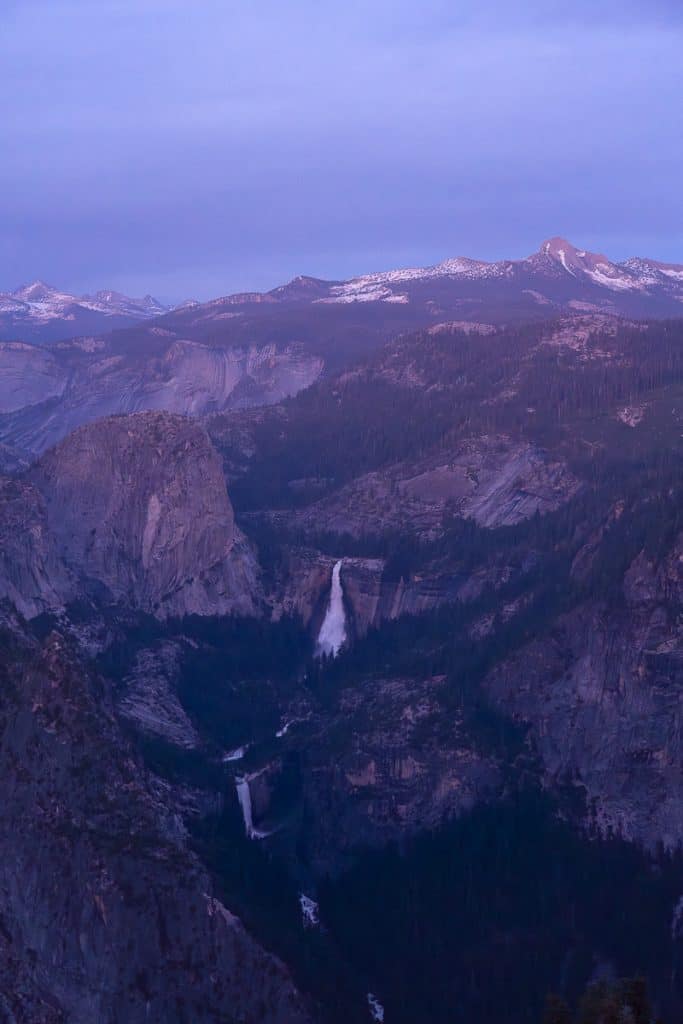
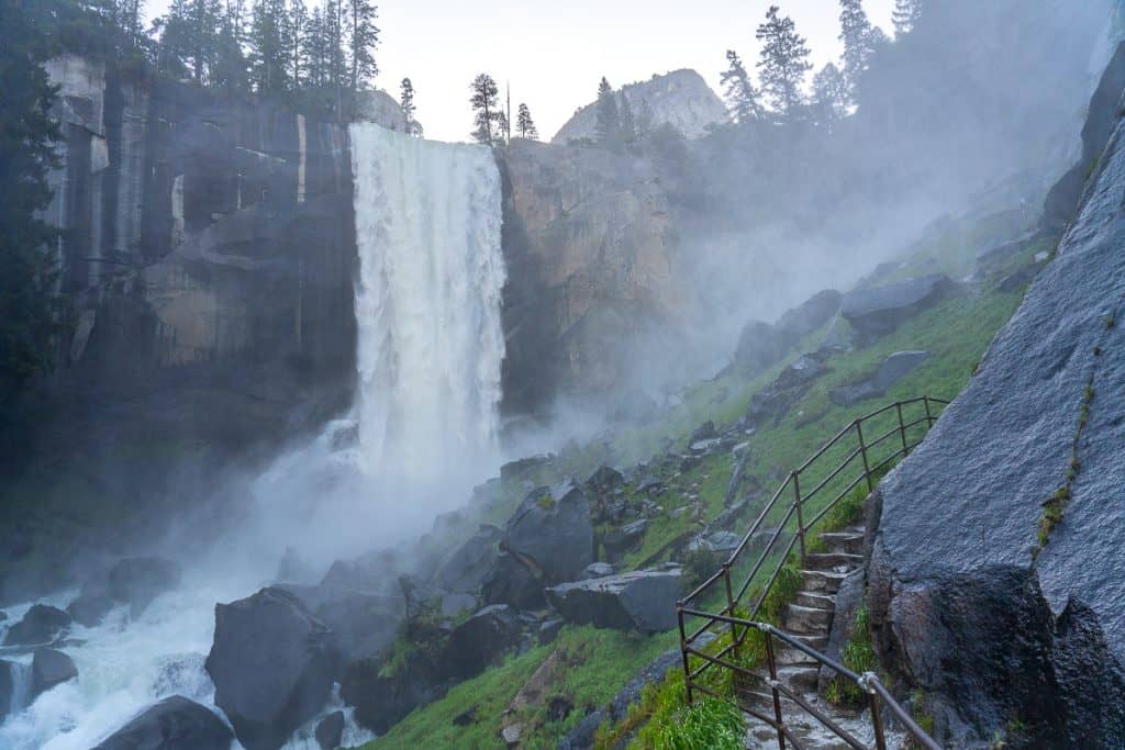
6. Vernal & Nevada Falls via the Mist Trail – John Muir Trail Loop
If there is one hike you have to do in Yosemite, it’s the Mist Trail. It’s iconic for a reason!
I recommend hiking the full Mist Trail – John Muir Trail Loop if you’re able to. You’ll get all of the best views and experience both Vernal and Nevada Falls from different angles and viewpoints. Plus, you get to hike a portion of the famous John Muir Trail!
One of my personal favorite views of Vernal Fall is from Clark Point – on the connector trail between the Mist Trail and JMT. I think it’s worth the detour, no matter which route you’re taking!
There are a few ways to make this hike shorter if you need to:
- Vernal Fall Footbridge: 1.6 miles | 400 feet | Easy
- Mist Trail to Vernal Fall & Clark Point: 4.5 miles | 1,600 feet | Moderate
However you decide to hike this trail, I’d always recommend doing it in a clockwise loop. Going downhill on the huge steps of the Mist Trail is no fun, and not super safe either, especially when the majority of hikers are going up the steps (and uphill hikers have the right of way)! It’s faster and easier on the knees to take the JMT downhill to the trailhead.
Pro Tip: Waterfalls are at their peak from late spring – early summer. Bring a rain jacket during this time & be prepared to get soaked on the trail! Trekking poles will also help with the large steps and stability.
Trail Info
- Distance: 6.4 miles
- Elevation Gain/ Loss: 2,200 feet
- Trail Type: Loop
- Difficulty: Strenuous
- Trailhead: Happy Isles (shuttle stop #16)
- Scenery Rating: 5/5
- Check current conditions and download on AllTrails
Notice: The Mist Trail is closed from 7 am – 3:30 pm on Monday – Thursdays through 10/30/2025. In order to get to the top of Vernal Fall, you need to take the John Muir Trail to the Clark Point Connector Trail & Vernal Fall, and then the Mist Trail to the top of Nevada Fall.
The full Mist Trail is open Fridays – Sundays.

7. Four Mile Trail to Glacier Point
The Four Mile Trail has some of the best views of all of Yosemite Valley, and has better views of Yosemite Falls than the actual Yosemite Falls trail! It also tops out at Glacier Point – one of the most amazing viewpoints in the entire park.
It’s pretty challenging though and steep. I also don’t think the small side trail to Union Point is necessary – the views above Union Point are just as good and even better since you’re higher up.
Be aware that it’s longer than 4 miles one way, despite the name of the trail. If you didn’t want to go uphill, you could take the paid Glacier Point Shuttle to the top and hike back down to the valley floor.
Pro tip: You can’t hike up and take the paid shuttle back to the valley floor – they only sell one-way tickets to Glacier Point.
Trail Info
- Distance: 9.6 miles
- Elevation Gain/ Loss: 3,200 feet
- Trail Type: Out & Back
- Difficulty: Strenuous
- Trailhead: Four Mile Trailhead (shuttle stop #11)
- Scenery Rating: 5/5
- Check current conditions and download on AllTrails

8. Upper Yosemite Falls
For some godforsaken reason, I’ve only ever backpacked this trail, so my opinions of it are pretty skewed – I think it’s SO. HARD.
The switchbacks going up the side of the upper falls seem never-ending, and they’re completely exposed to the sun for most of the day, so it just feels HOT.
The views are pretty amazing though – so I’d say it is worth it, just be prepared for a bit of a sufferfest.
Once you’re at the top, add on the extra 2 miles roundtrip to Yosemite Point – slightly above the falls. You’ve already come this far – and the view of Half Dome is even better up there!
Can’t make it all the way to the top? The view from Columbia Rock, about a mile into the trail is still a worthy hike – the view of Half Dome and the valley floor is pretty great!
Trail Info
- Distance: 7.2 miles
- Elevation Gain/ Loss: 2,900 feet
- Trail Type: Out & Back
- Difficulty: Strenuous
- Trailhead: Camp 4 (shuttle stop #7)
- Scenery Rating: 5/5
- Check current conditions and download on AllTrails

9. Snow Creek Trail
This is the trail that no one ever talks about and is seldom hiked. Most people miss it because the trailhead is actually tucked away at the back of Mirror Lake and it’s uphill sections have the steepest grade in Yosemite!
But I think it’s worth the sufferfest. You get some of the most unique views of Half Dome in the entire valley, and can see the elusive Tenaya Creek Falls above Mirror Lake! You can also see Illilouette Fall tucked away in a ravine from the highest points of the trail.
The Snow Creek Trail is also the most direct route from the Valley to Tioga Road.
I definitely recommend hiking poles for this one and to get an early start to the day. There’s some shaded areas, but the trail is mostly exposed on the switchbacks to the rim.
Trail Info
- Distance: 9.4 miles
- Elevation Gain/ Loss: 2,900 feet
- Trail Type: Out & Back
- Difficulty: Strenuous
- Trailhead: Mirror Lake (shuttle stop #17)
- Scenery Rating: 5/5
- Check current conditions and download on AllTrails

10. Mist – Panorama – 4 Mile Trail Semi-Loop
I finally decided to tackle this almost-loop last summer and I’m so happy I did! It took me almost 10 hours to complete this hike with plenty of photo breaks along the way.
My favorite parts were on the Panorama Trail: the overlook at Panorama Point and Illilouette Fall. The views of Half Dome are unlike anywhere else in the park: you get to see more of the curved, dome side vs. the face, and have more views of other high country peaks.
I started by ascending the Mist Trail in the early morning to beat the crowds and avoid hiking DOWN the Mist Trail in the afternoon when hordes of people would be on the trail. I think this is the best way to do the hike. The biggest downside is ascending the trail to Glacier Point: its pretty exposed and hot midday.
Trail Info
- Distance: 13.5 miles
- Elevation Gain/ Loss: 4,200 feet
- Trail Type: Point-to-point
- Difficulty: Strenuous
- Trailhead: Happy Isles (stop #16) or Four Mile (stop #11)
- Scenery Rating: 5/5
- Check current conditions and download on AllTrails

11. Half Dome
Half Dome is probably the most iconic rock formation inside the park, and the most brave and lucky hikers get a chance to hike to the top!
Half Dome is the only day hike that requires a permit in Yosemite, and you have to enter a lottery ahead of time to have a chance to win. Rangers are checking permits daily at the Subdome to ensure everyone has a permit.
This hike is not for the faint-hearted. I completed it way back in 2016 and still think it’s one of the hardest day hikes I’ve ever done. You take the Mist Trail up to the top of Nevada Fall and the John Muir Trail through Little Yosemite Valley before climbing up the Half Dome Trail to the base of Subdome.
Subdome is where the trail gets a little scarier and more like a rock scramble before you reach the bottom of the infamous “cables” section, where you use wooden footplanks and metal cables to help ascend the rest of the way up Half Dome.
I thought coming down the cables was scarier than going up – but wearing gardening gloves with a grippy palm was really helpful in feeling more secure on the slippery metal cables.
Trail Info
- Distance: 16 miles
- Elevation Gain/ Loss: 5,000 feet
- Trail Type: Out & Back
- Difficulty: Strenuous
- Trailhead: Happy Isles (shuttle stop #16)
- Scenery Rating: 5/5
- Check current conditions and download on AllTrails
No Stress Yosemite Planning
Download my free reservation & permit guide so you know which ones you need & you never miss a release date.
Best Hikes on Tioga Road and Tuolumne Meadows
Hiking in Yosemite’s northern country is one of the best ways to escape the summer heat and crowds of Yosemite Valley.
While Yosemite Valley hikes are all about jaw-dropping views, Tuolumne hikes have more alpine lakes, wildflowers, meadows, and forest. And quite a few still have seriously stunning views.
Be aware that altitude can be an issue for some people in Yosemite’s high country. All of the hikes listed here start at least 7,000 feet above sea level – some even higher. Acclimatization can take time – drink plenty of water with electrolytes and rest when you need to, and know the signs & symptoms of Acute Mountain Sickness (AMS).
Tioga Road from Crane Flat to Tioga Pass is only open in the summer & fall, usually late-May to mid-November. So you have to visit the park during this time to hike these trails!

12. Soda Springs & Parsons Lodge
Soda Springs is like a mini Yellowstone inside of Yosemite! Cold, carbonated water bubbles out of the ground in this one particular area!
This is a very mild hike from the Tuolumne Meadows Visitor Center on a path through the large meadow and over to the springs and historic lodge.
The views of the entire meadow area and the Tuolumne River are really pretty and its definitely worth a stop!
Trail Info
- Distance: 1.4
- Elevation Gain/ Loss: Mostly flat
- Trail Type: Out & Back
- Difficulty: Easy
- Trailhead: Tuolumne Meadows Visitor Center
- Scenery Rating: 3/5
- Check current conditions and download on AllTrails

13. Pothole Dome
This is one of my favorite hidden-in-plain-sight adventures in Yosemite! It’ll have you feeling like a kid again, since there isn’t really a trail up the dome – you just scramble your way up to the top!
The views from the summit of the dome are way more amazing than you’d think. You’ll see all of Tuolumne Meadows including Lembert Dome to the east, and to the northwest: the Grand Canyon of the Tuolumne and all of the granite domes along the way.
Pro tip: Do this hike at sunset for the best views!
Trail Info
- Distance: 1 mile
- Elevation Gain/ Loss: 200 feet
- Trail Type: Out & Back
- Difficulty: Easy
- Trailhead: Pothole Dome Parking
- Scenery Rating: 4/5
- Check current conditions and download on AllTrails

14. Lyell Canyon via the John Muir Trail
I love the hike into Lyell Canyon. Woods quickly turn to meadows and the creeks are so serene, and great for hanging out around and getting to dip in.
A natural turnaround point are the bridges over the Lyell Fork, but if you’re able to make it further into the canyon to where the ridgeline becomes more visible, I urge you to. Hiking about 3 miles into the canyon gets you there.
Trail Info
- Distance: 6.5 miles (to the opening of the canyon)
- Elevation Gain/ Loss: 300
- Trail Type: Out & Back
- Difficulty: Easy
- Trailhead: Pacific Crest Trail/ John Muir Trail South
- Scenery Rating: 3/5
- Check current conditions and download on AllTrails

15. Dog Lake & Lembert Dome
Dog Lake isn’t the most popular hike in Yosemite, but I really loved the views of Mount Dana and Mount Gibbs at the back of the lake, and it was super peaceful when I visited.
If you want to hike around the hike, you can do so by adding another mile to these stats.
Lembert Dome is a must-add if you want a great view of Tuolumne! I still haven’t made it to the top of Lembert – it’s on my list for the next visit, I’ve been wanting to go for so long!
Trail Info
- Distance: 3.8 miles
- Elevation Gain/ Loss: 850 feet
- Trail Type: Out & Back
- Difficulty: Moderate
- Trailhead: Dog Lake Parking
- Scenery Rating: 3/5
- Check current conditions and download on AllTrails

16. May Lake
May Lake is one of the most gorgeous alpine lakes in Yosemite, and the hike is short & fairly easy!
I visited May Lake as part of a longer backpacking trip after a high snow winter, and there were icebergs in the lake in mid-July! I camped at the high sierra backpacker’s campground. I can’t wait to go back when it’s a little more summery.
If you’re wanting a little more of a challenge, tack on a summit of Mt. Hoffman, which towers over May Lake at 10,853 feet. It’s also the geographic center of all of Yosemite National Park – pretty neat!
Trail Info
- Distance: 2.4 miles
- Elevation Gain/ Loss: 485 feet
- Trail Type: Out & Back
- Difficulty: Easy
- Trailhead: May Lake
- Scenery Rating: 5/5
- Check current conditions and download on AllTrails

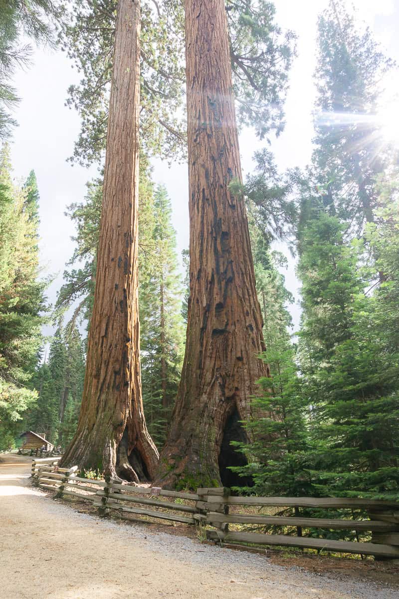
17. Tuolumne Grove of Sequoias
Mariposa Grove in the south of the park isn’t the only grove of giant Sequoia trees in Yosemite! The Tuolumne Grove is near Crane Flat, making it more convenient to people driving in from the Big Oak Flat Entrance.
I did this hike as a winter snowshoe in February one year and it was a lot of fun. The Sequoia trees aren’t as enormous as the ones in Mariposa Grove, but it was so quiet, we felt like we had the whole trail to ourselves, and we got to hike through an arch in a burned-out Sequoia Tree which was pretty cool.
Trail Info
- Distance: 2.5 miles
- Elevation Gain/ Loss: 500 feet
- Trail Type: Out & Back
- Difficulty: Easy
- Trailhead: Tuolumne Grove
- Scenery Rating: 3/5
- Check current conditions and download on AllTrails

18. Gaylor Lakes
A true high alpine hike in Yosemite. This trail starts right next to the Tioga Pass Entrance Station at nearly 10,000 feet and begins climbing straight away.
I completely underestimated this hike when I did it back in 2017. I thought since it was so short it wouldn’t be an issue but WOW the altitude totally got me, even though I’d been camping in Tuolumne Meadows all weekend!
Me & my friends stopped so many times – the views are amazing though, so I didn’t feel too guilty for stopping.
We just went to the first lake, but the trail does continue up to the eastern border of Yosemite where there’s an old mine. The trail is pretty faint after the main lake, so just be aware of your surroundings and have the hike GPS track downloaded.
Trail Info
- Distance: 2.6 miles
- Elevation Gain/ Loss: 500 feet
- Trail Type: Out & Back
- Difficulty: Moderate
- Trailhead: Gaylor Lakes/ Tioga Pass
- Scenery Rating: 5/5
- Check current conditions and download on AllTrails

19. Sunrise Lakes
Sunrise Lakes shares the same trailhead and trail as the popular Cloud’s Rest hike – but everyone is so focused on Cloud’s Rest that they skip the lakes!
I visited Sunrise Lakes as part of a longer backpacking trip and really enjoyed them. I spent all afternoon relaxing (and getting sunburned) on the rocks by the lakes, swimming, and enjoying nature.
The hike up is pretty steep, but the views of the high country mountains are worth it!
Do be aware that the first thing you have to do on this hike is cross Tenaya Creek – and it is not bridged.
Trail Info
- Distance: 6.9 miles
- Elevation Gain/ Loss: 1,600 feet
- Trail Type: Out & Back
- Difficulty: Moderate
- Trailhead: Sunrise Lakes Trailhead at Tenaya Lake
- Scenery Rating: 4/5
- Check current conditions and download on AllTrails

20. Cathedral Lakes
Cathedral Lakes is definitely one of the best day hikes in Yosemite – and I think it’s a can’t-miss if you’re a first-time visitor!
The hike itself isn’t the most exciting – you’re mainly hiking through forest, but once you actually get to the lakes – it’s magic!
I’ve camped at Upper Cathedral Lake twice now and I think it’s stunning. You’ll want to travel to the south side of the lake for the iconic views of Cathedral Peak and the chance to scramble up the granite slope for an even better bird’s eye view.
I haven’t taken the extra 1.4 mile round-trip detour to Lower Cathedral Lake myself, but the photos I’ve seen look stunning and it’s probably worth the side trip if you have the time and energy!
Trail Info
- Distance: 8 miles
- Elevation Gain/ Loss: 1,250 feet
- Trail Type: Out & Back
- Difficulty: Moderate
- Trailhead: Cathedral Lakes Trailhead on Tioga Road or Tuolumne Meadows Visitor Center (more parking)
- Scenery Rating: 5/5
- Check current conditions and download on AllTrails
21. Glen Aulin via the Pacific Crest Trail
Glen Aulin screams “Sierra summer swimming hole”. If you want to hike through a gorgeous river canyon and get to swim in an ice-cold pool at the base of a waterfall, this is the hike for you.
I’ve visited Glen Aulin on 3 separate backpacking trips, and I love it more and more every time I get to go. The hike itself is gorgeous – you’re following the Tuolumne River the whole time, and you get views of the Grand Canyon of the Tuolumne consistently for the second half of the trail.
You’ll pass multiple rapids, cross the river on bridges, and marvel at multiple waterfalls on your way down to White Cascade at Glen Aulin.
Be aware that this hike is downhill – all the elevation gain will be on the way back to the trailhead, so don’t tire yourself out too much!
Pro tip: The view from the footbridge at Glen Aulin is awe-inspiring – definitely don’t miss it. Also, take the trail down below Glen Aulin for just another quarter of a mile to see another granite-slab waterfall and a quieter place to swim in the river.
Trail Info
- Distance: 10.7 miles
- Elevation Gain/ Loss: 1,150 feet
- Trail Type: Out & Back
- Difficulty: Moderate
- Trailhead: Glen Aulin Trailhead/ Lembert Dome Parking
- Scenery Rating: 4/5
- Check current conditions and download on AllTrails

22. North Dome
It’s a bit of a sleeper option, but as I said at the top of this post, I think North Dome is a must-do hike in Yosemite!
The view of Half Dome from North Dome is outstanding. You are literally right across from the face of Half Dome – nothing but air separates you! It’s pretty incredible.
Another cool feature of this hike is the short but steep side trail to Indian Arch – the only natural, granite arch in Yosemite! Definitely make the detour to see it – it’s one of the most unique and least talked about spots in the park.
Pro tip: This is another hike that starts as downhill first, so just be ready for the harder hike back to the parking lot!
Trail Info
- Distance: 10.4 miles
- Elevation Gain/ Loss: 2,000 feet
- Trail Type: Out & Back
- Difficulty: Strenuous
- Trailhead: Porcupine Creek
- Scenery Rating: 5/5
- Check current conditions and download on AllTrails

23. Cloud’s Rest
This is the hike I always recommend for anyone who is disappointed they didn’t win Half Dome permits. But it is definitely not a consolation prize!
The Cloud’s Rest hike itself is a little “meh” – you’re in the forest for most of it – but once you break above the trees and you’re scrambling up the rock ledge to the actual point – your mind will be blown.
Having been at the top of Cloud’s Rest and Half Dome, I think the view from Cloud’s Rest is better – you get to actually see Half Dome from Cloud’s Rest! Plus, you get to see more of the mountains to the east and Tenaya Lake.
Pro tip: Get started early. This parking lot fills up fast, and you’ll want to give yourself plenty of time to complete this hike!
Trail Info
- Distance: 12.4 miles
- Elevation Gain/ Loss: 3,110 feet
- Trail Type: Out & Back
- Difficulty: Strenuous
- Trailhead: Sunrise Lakes Trailhead at Tenaya Lake
- Scenery Rating: 5/5
- Check current conditions and download on AllTrails
Best Hikes on Glacier Point Road & Wawona
Like northern Yosemite, southern Yosemite is a seasonal spot. Glacier Point & Mariposa Grove Roads are closed in the winter, but slightly more accessible than Tioga Road for those looking for winter hiking adventures.
In general though, all of the hikes listed below will be best completed in the summer & fall months.

24. Glacier Point
Glacier Point isn’t just a viewpoint – there’s actually quite a bit of short, paved paths in the area. Start at the amphitheater and make your way past the Geology Hut as you walk to the actual viewpoint.
You’ll get a slightly different view of the area as you keep walking. And trust me, you’ll want to soak up as much of this view as possible!
Pro tip: Sunrise & sunset are the best times to enjoy Glacier Point.
Trail Info
- Distance: 0.5 miles
- Elevation Gain/ Loss: 50 feet
- Trail Type: Out & Back
- Difficulty: Easy
- Trailhead: Glacier Point
- Scenery Rating: 5/5
- Check current conditions and download on AllTrails

25. Swinging Bridge
This is a quiet little hike tucked away in the Wawona area that’s a great, low-key spot to hang out at later in the summer to escape crowds and swim in the river!
Pro tip: The AllTrails description has you hiking from the Chilnualna Falls trailhead, which you can do, but to make the hike shorter, you can drive to the Swinging Bridge parking lot on the other side of the river at the end of Forest Drive.
Trail Info
- Distance: 0.6 miles
- Elevation Gain/ Loss: mostly flat
- Trail Type: Out & Back
- Difficulty: Easy
- Trailhead: Swinging Bridge Trailhead
- Scenery Rating: 3/5
- Check current conditions and download on AllTrails
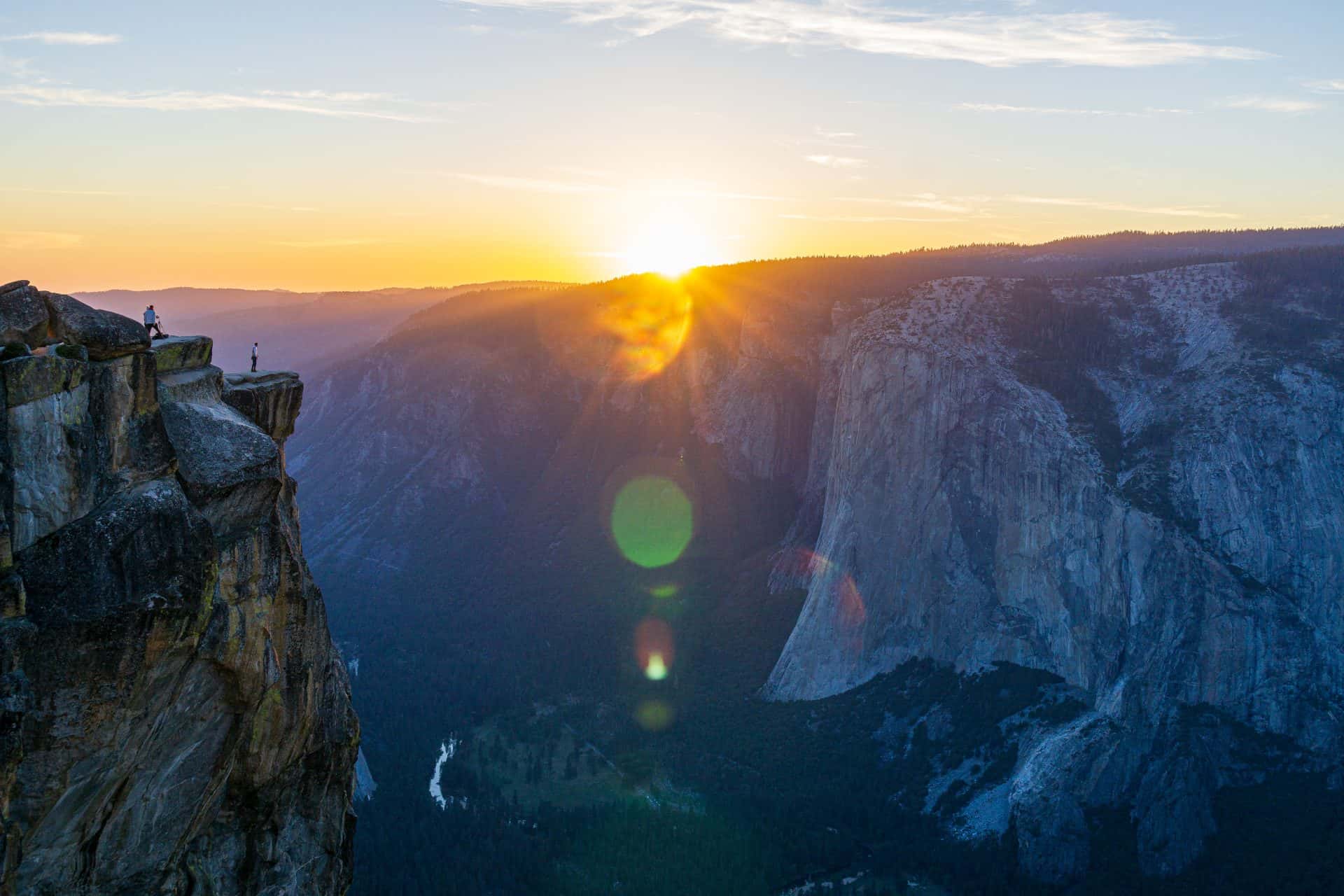
26. Taft Point
This is one of those can’t miss hikes in Yosemite! Taft Point is pretty amazing – the views of El Capitan from above will make you say “wowza”, and the view of Yosemite Falls is spectacular as well.
The hike starts off in the forest going downhill and eventually ends up at the rim of the Valley.
And just so you know, bears love this area! I saw a bear on the actual trail, and on another trip a couple of bears on the Pohono Trail close to Taft Point.
Pro tip: This is another hike that’s sunrise & sunset worthy. It’s a short hike, so you won’t have to hike far in the dark, but bring a headlamp or flashlight if you choose to see it this way!
Trail Info
- Distance: 2.2 miles
- Elevation Gain/ Loss: 200 feet
- Trail Type: Out & Back
- Difficulty: Easy
- Trailhead: Sentinel Dome/ Taft Point Trailhead
- Scenery Rating: 5/5
- Check current conditions and download on AllTrails
27. Grizzly Giant Loop Trail
The Grizzly Giant is the biggest sequoia tree in the Mariposa Grove and it’s definitely impressive!
If you only have time for a short hike in Mariposa Grove, this is the one I’d recommend. But if you have more time, hike to some other notable trees!
Pro tip: Mariposa Grove Road is closed to private vehicles when the shuttle is operating (except if you have a disability placard). Check out the shuttle times here. You can still visit the grove before & after these shuttle times, and you can park at the grove entrance!
Trail Info
- Distance: 2 miles
- Elevation Gain/ Loss: 300 feet
- Trail Type: Loop
- Difficulty: Easy
- Trailhead: Mariposa Grove Arrival Area
- Scenery Rating: 4/5
- Check current conditions and download on AllTrails

28. Dewey Point
Taft Point may be an easier hike to the valley rim, but Dewey Point is for those who want to get away from the crowds and still get an amazing view of El Capitan and the valley floor!
This hike begins in the forest and wildflower-filled McGurk Meadow. You’ll hike past an old cabin before joining the Pohono Trail and climbing up to Dewey Point.
I finally got to see this spot this summer when I backpacked the Pohono Trail – and I really loved it! It has such a unique view of El Capitan. I’d try to get there earlier in the morning or later in the afternoon to witness the glow of sunlight streaming through the valley.
Trail Info
- Distance: 7.6 miles
- Elevation Gain/ Loss: 750 feet
- Trail Type: Out & Back
- Difficulty: Moderate
- Trailhead: McGurk Meadow
- Scenery Rating: 5/5
- Check current conditions and download on AllTrails

29. Mariposa Grove of Giant Sequoias to Wawona Point
If you’re up for a longer hike through Mariposa Grove, this is the hike for you!
The view from Wawona Point isn’t jaw-dropping – mainly just overlooking the forest of trees – but it’s rarely visited, so perfect for those who are looking for some peace.
Pro tip: There are multiple trails you can take to get to Wawona Point, making this hike longer if you choose. You might want to make a few short detours to the Columbia and Galen Clark Trees that are just off the main Mariposa Grove Trail.
Trail Info
- Distance: 7.75 miles
- Elevation Gain/ Loss: 1,200 feet
- Trail Type: Out & Back
- Difficulty: Moderate
- Trailhead: Mariposa Grove Arrival Area
- Scenery Rating: 4/5
- Check current conditions and download on AllTrails
30. Panorama Trail to Illilouette Fall
The Panorama Trail is one of the best secrets in Yosemite! The trailhead is at the crazy-popular Glacier Point, but relatively few people hike down the trail and to the elusive Illilouette Fall.
I think this should be on everyone’s to-hike list: you get amazing views of Half Dome, Vernal, and Nevada Falls, and of course, Illilouette Fall, and the hike isn’t too challenging.
I’d also recommend hiking further than the fall overlook to Illilouette Creek to enjoy the creek that is more like a raging river and a little further to Panorama Point where the views of the granite walls around you are pretty awe-inspiring.
Trail Info
- Distance: 5.2 miles
- Elevation Gain/ Loss: 1,430 feet
- Trail Type: Out & Back
- Difficulty: Moderate
- Trailhead: Glacier Point
- Scenery Rating: 5/5
- Check current conditions and download on AllTrails

31. Chilnualna Falls
I finally hiked to the lower falls earlier this spring and would have kept going, but it was getting late. So I still need to go back and get to the top cascades!
But I really enjoyed the lower cascade and thought it was super pretty, and liked hiking up next to the river above it.
You’ll want to save this hike for spring & early summer. The Wawona area is lower elevation and gets hot in the summer, plus, the waterfall eventually dries up.
Trail Info
- Distance: 8.2 miles
- Elevation Gain/ Loss: 2,400 feet
- Trail Type: Out & Back
- Difficulty: Strenuous
- Trailhead: Chilnualna Falls
- Scenery Rating: 3/5
- Check current conditions and download on AllTrails

32. Pohono Trail
The Pohono Trail is usually done as a backpacking trip, but you could do it as a day hike if you have a shuttle car, take the Glacier Point shuttle, or are ok with hitchhiking.
You’ll hike from Glacier Point along the southern rim of the valley. The trail weaves in and out of forested areas, popping out at the most impressive overlooks.
My personal favorite viewpoints are Taft Point and Crocker Point.
Trail Info
- Distance: 12.2 miles
- Elevation Gain/ Loss: 2,000/ 5,000 feet
- Trail Type: Point-to-point
- Difficulty: Strenuous
- Trailhead: Glacier Point
- Scenery Rating: 5/5
- Check current conditions and download on AllTrails
Best Hikes in Hetch Hetchy
Hetch Hetchy has its own, separate park entrance and is visited a lot less than other parts of Yosemite since it’s a bit out of the way.
There aren’t a ton of day hikes in this area, but I still think it’s worth a visit – especially in spring and early summer!

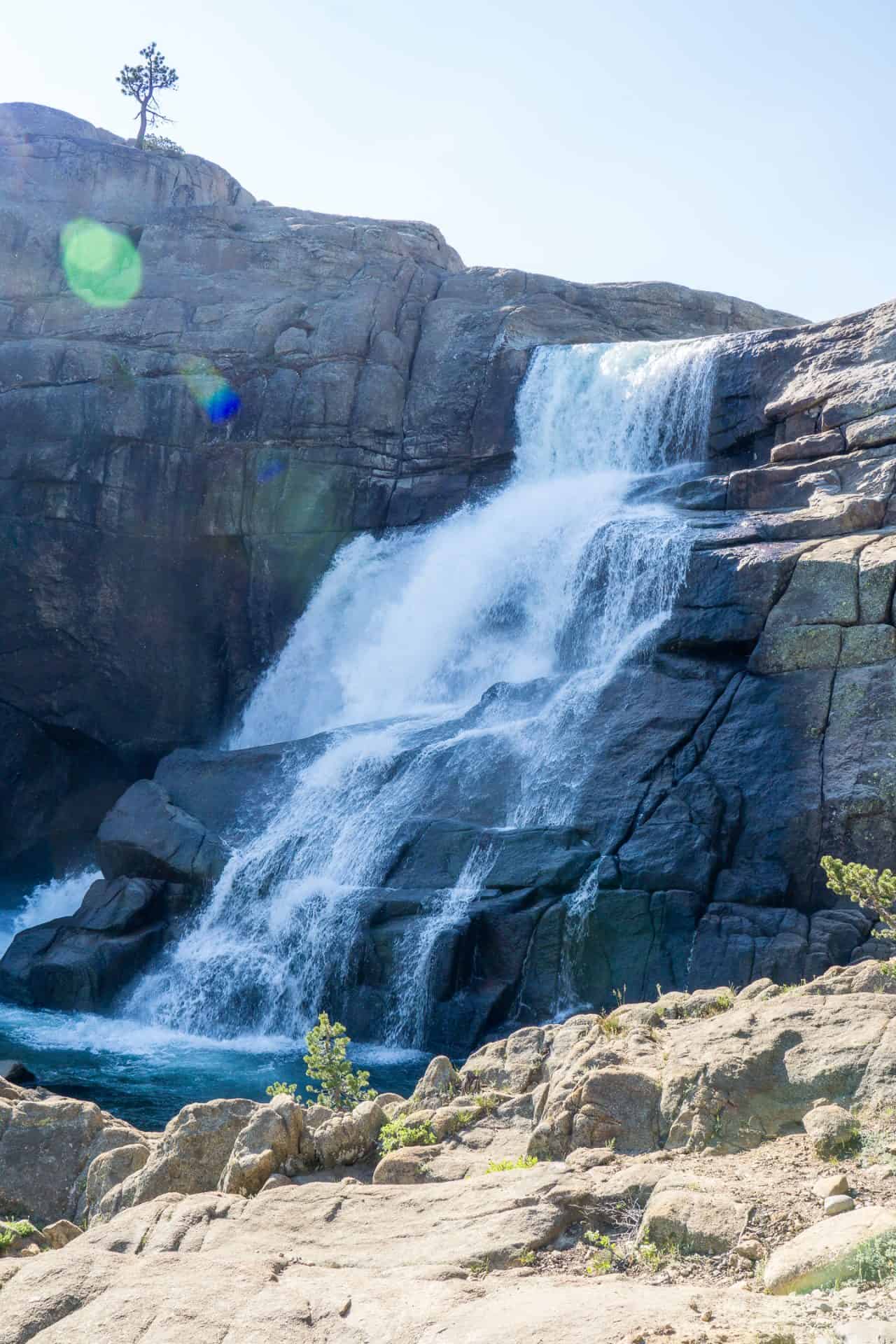
33. Tueeulala & Wapama Falls
This might be the most underrated waterfall hike in the entire park! You get to walk across and along the Hetch Hetchy reservoir, marveling at Kolana Rock for nearly the entire hike.
The trail is relatively flat with just a couple of spots of elevation gain, making it great for all hiking abilities.
I was lucky to hike this trail at peak snowmelt time and the flow at Wapama Falls was strong! I got soaked walking across the footbridge and it felt AMAZING! If you’re visiting Yosemite in late May-early June, definitely do this hike.
Pro tip: This trail can get hot, and the sun shines directly on the path from morning – mid afternoon. Wear sun protective clothing and bring plenty of water!
Trail Info
- Distance: 5 miles
- Elevation Gain/ Loss: 507 feet
- Trail Type: Out & Back
- Difficulty: Moderate
- Trailhead: O’Shaughnessy Dam
- Scenery Rating: 4/5
- Check current conditions and download on AllTrails

Top Tips For Day Hiking in Yosemite
Leave No Trace
Following the seven principles of Leave No Trace is super important when you’re visiting and hiking through Yosemite. We want to keep this place pristine for everyone – whether they visit tomorrow or 50 years from now.
The best ways to do this while day hiking are by staying on trail and not creating shortcuts on trails, packing out your waste properly (orange peels and apple cores and toilet paper should NOT be left behind), and leaving nature in place (i.e. no flower picking or rock collecting and leave any artifacts behind).
These are all of the principles:
- Plan ahead and prepare – hey you’re doing this right now! Gold star!
- Travel and camp on durable surfaces
- Dispose of waster properly
- Leave what you find
- Minimize campfire impacts
- Respect wildlife – do not approach, touch, or feed
- Be considerate of others
Park Entry & Cost
It costs $35 to drive into Yosemite National Park in a private vehicle.
I recommend most people purchase an America the Beautiful pass. For only $80, you get entry to every national park, national monument, forest service area, or BLM region – for an entire year!
👉 New for 2026: America the Beautiful Pass Price Increases for Non-US residents.
Hiking Permits
The only day hike that requires a permit is Half Dome. Otherwise, you don’t need a special permit to hike any of the other trails in Yosemite!
Overnight hiking does require a permit, which is reservable by a lottery system.

Seasons & Weather
Yosemite is most accessible for hiking in the summer-fall months. This is when the majority of the snow has melted and all of the park roads are open.
If you’re visiting in the winter or spring, you’ll want to stick to hikes in Yosemite Valley, Hetch Hetchy, and Wawona. There can still be snow on trails during this time, so you should be prepared for winter hiking conditions.
The most important thing to be aware of while hiking in the summer is that Yosemite experiences thunderstorms – mainly in June and July.
Always get a weather report before going hiking in the park – especially if you plan on hiking peaks like Half Dome or Cloud’s Rest. And don’t be afraid to turn around if you see storm clouds forming. Multiple people have died from lightning strikes in Yosemite.
If you’re planning to visit the high country, be aware that snow can fall – even in the summer! Storms can move in and out quickly, so it could be short-lived, but those storms can get cold quickly and bring hail and snow with them. It’s important to pack a warm jacket and a rain jacket in your hiking pack for these instances!
Parking & Trailheads
Parking can be difficult in Yosemite! Pretty much every parking space can be filled at the height of summer.
I’d recommend getting to longer and popular hikes as early in the day as possible – ideally before 8 am to ensure you get a spot.
If you’re hiking in Yosemite Valley, try to park at the Visitor Center or Trailhead Parking near Curry Village and take the free park shuttles to the various trailheads in the Valley.
The Mariposa Grove Welcome Plaza has a very large parking lot, and shouldn’t be an issue to park here, but you may have to wait in line for a shuttle depending on how crowded it is. Going in the early morning or later in the day will be best.
Most trailheads in Yosemite have pit toilets, trash receptacles, and bear lockers, but very few have running water, so always make sure you fill your water bottles up before you get to a trail!
Remember to practice proper food storage at trailheads. You are allowed to keep scented items in your car during the day as long as the windows are kept rolled up and nothing is visible inside the car – wrappers, drink bottles, or coolers. Food and coolers should never be left in an open truck bed.

Pets On Trail
In general, Yosemite is not very pet-friendly for hikers. Pets (including emotional support and therapy dogs) are not allowed on trails, in meadows, on beaches, or in waterways (like any creek or lake).
They are allowed on paved roads, sidewalks, and bicycle trails, making Yosemite Valley one of the best places for them to hang out.
Pets are also allowed on these trails ONLY, and must be on a 6-foot leash:
- Bridalveil Fall
- Lower Yosemite Fall
- Cooks Meadow Loop
- Mirror Lake (paved portion only)
- Wawona Meadow Loop

Bears & Other Wildlife
Most people’s biggest concern when hiking in Yosemite is running into a bear.
Yosemite is home to black bears, and I’ve been lucky enough to come across them multiple times while hiking in the park – in every single section of the park.
Bears do use the hiking trails in the park simply because… they’re lazy! It’s easier to walk on trails to find food than on lumpy ground off-trail.
If you see a bear on trail in Yosemite, don’t panic. Stop hiking, make your presence known by talking loudly at the bear. Usually a loud “HEY BEAR” does the trick. If the bear is on the trail and looks like they want to continue walking on the trail, you should move off trail to let the bear pass. Always try to give bears 100-200 feet of space.
Bear spray is illegal in Yosemite, so don’t carry or deploy it. Black bears have never caused death to a human in Yosemite, and there are no grizzly or brown bears here.
For all other wild animals – just remember that they’re wild. Don’t feed them, touch them, or approach them (yes, that includes birds and chipmunks too). They carry disease, and human food is unhealthy for them.
Best Hike Planning Resources
When I go to Yosemite, I always download maps offline – Google driving maps and my trail maps!
I use AllTrails Plus to download routes and have maps available offline for all of my day hikes.
If you want to try AllTrails Plus (or Peak for even more features), you can use my code “backcountryemily30” for 30% off your subscription!

Hiking Gear You Should Have
Out hiking you should always carry the 10 essentials in case something happens and to be safe. But there are a few other items that you should consider to be safe & happy on Yosemite’s trails. If you’re new to hiking or not sure what the 10 essentials are, check out my hiking basics guide!
Sweat Wicking Clothing
You’ll definitely work up a sweat hiking in Yosemite! I’ve been loving natural alpaca fiber sun hoodies because they wick sweat and keep my body temperature well regulated – much better than polyester and cotton!
Trekking Poles
These are so helpful for Yosemite’s steepest trails, especially if you don’t like drop offs or heights. They provide stability, give you a little boost, and prevent your hands from swelling from the intense activity.
These poles are great for most hikers.
Water Filter
If you’re doing any of the longer hikes in Yosemite – like Half Dome or Cloud’s Rest, bringing a water filter is handy so you can refill your water in case you run out.
I always bring the Sawyer Squeeze with me.
Supportive Shoes
I am a die-hard trail runner girl, so you’ll find me in Altra Lone Peaks all the time. Head to REI to get fitted for a hiking shoe or boot that works best for your feet.
I just wouldn’t recommend regular sneakers – they’ll get dirty and they don’t have great traction on the slick granite that covers a lot of Yosemite trails.
Warm & Dry Layers
Weather can change in an instant in Yosemite. I always recommend carrying a lightweight puffy or fleece jacket in addition to a rain jacket or poncho when you’re hiking through Yosemite.
Sun Protection
Sunscreen is a must when you’re out hiking in Yosemite. Some trails have tree cover, but most are pretty exposed. Don’t forget your lips too!
Backpack
You don’t need a huge pack, but having something that fits you well and can carry all of the 10 essentials, water, and food for your day is smart. I’d recommend getting fitted for a day pack at REI.

FAQ About Day Hiking in Yosemite
I only have one day in Yosemite – which hike should I do?
If you have one day in Yosemite Valley, hike the Mist Trail to Vernal and Nevada Falls. If you’re in Tuolumne Meadows or driving through on Tioga Road, hike to Cathedral Lakes.
What is the best easy hike in Yosemite?
My favorite easy hike is definitely Taft Point! The views are unmatched.
What is the best medium difficulty hike in Yosemite?
I think Cathedral Lakes is the best moderate hike in the park. The views of Cathedral Peak are so beautiful and the swimming is amazing!
What is the best hard hike in Yosemite?
The Mist – Panorama – Four Mile Trail partial-loop has got to be it. You get to see the majority of the major waterfalls in Yosemite and multiple views of Half Dome. It’s pretty incredible!
Do I need a permit to hike in Yosemite?
Generally, no. The only day hike that requires a permit is Half Dome.
Is it safe to hike in Yosemite?
Hiking always carries inherent risks. I don’t think it is unsafe to hike in Yosemite, but you should always respect nature, know your personal limits, and pay attention to the weather and your surroundings, like any other hiking area.
When is the best time of year to hike in Yosemite?
Summer is the best time to hike in Yosemite. Most trails are open in the park, and hazards like snow and below freezing temperatures are gone except in the most extreme areas.
Can I bring my dog hiking in Yosemite?
Not really. Pets are only allowed on a handful of very short trails.
Should I bring bear spray to Yosemite?
No. Bear spray is prohibited in Yosemite.
Do I need a reservation to visit Yosemite in 2026?
Nope. No day-use reservations are required in 2026. You still need reservations for lodging inside the park.
Planning Your Yosemite Hiking Trip
Now that you have an idea of all the hiking Yosemite has to offer, it’s time to put it all together to make sure you can get the most out of your visit to the park!
I have the perfect three-day summer itinerary that features one moderate-hard hike each day of the trip, plus other must-see viewpoints and attractions along the way.
Visiting Yosemite for a different amount of time and want to chat about a more customizable itinerary or want more personalized hiking advice?
Book a 25 minute call with me on Outdoorable and use the code “schrick10” for $10 off! I’ll go over your preferences and be able to give you the best advice for your needs and trip.
Pin For Later

