15 Best Hikes in Sequoia National Park
Planning a trip to Sequoia National Park and trying to figure out which hikes are actually worth your time?
With limited time and hundreds of miles of trails in the park, it’s easy to stick to the obvious stops — but you might miss some of the best hikes entirely. While most people come for the giant sequoia trees, there’s so much more to explore here, from crystal clear alpine lakes to panoramic mountain views.
After multiple trips to Sequoia in both summer and winter, including 4 Mt. Whitney summits, I’ve put together this guide to the best hikes in the park — from easy walks to challenging full-day adventures — so you can quickly figure out which trails are worth adding to your itinerary. And if you’re short on time, I’ll also share exactly which hikes I’d prioritize.

Backcountry Emily contains affiliate links and I may receive compensation - at no extra cost to you! As an Amazon Associate I earn from qualifying purchases. See my Privacy Policy for more information.
Best Hikes for First-Time Visitors
If it’s your first time in Sequoia, these are the hikes I’d prioritize to get a mix of the park’s best features — giant sequoias, alpine scenery, and panoramic views:
- The Congress Trail: Best overall sequoia experience and the top hike if you only have time for one.
- Moro Rock: Short hike with the best panoramic views in the park.
- Tokopah Falls: Scenic river trail leading to a waterfall, especially strong in early summer.
- Pear Lake (Bonus): A challenging alpine hike for experienced hikers who want a full-day adventure. If you’re short on time, I’d swap this for Tokopah Falls.
Best Hikes in Sequoia National Park by Category
- General Sherman Tree Trail – Best for first-time visitors
- Moro Rock – Best views for minimal effort
- Congress Trail – Best overall sequoia experience
- Tokopah Falls – Best waterfall hike
- Mt. Whitney – Best summit hike
How to Plan Your Hikes in Sequoia (Quick Itinerary)
If you have:
- Half a day: Do Moro Rock + Congress Trail
- 1 full day: Add Tokopah Falls
- 2 days: Include a longer hike like Pear Lake or Alta Peak
- 3+ days: Visit Mineral King, hike Monarch Lakes
Remember, there’s more to see in Sequoia besides hiking trails, so if you don’t want to spend your whole day hiking, you’ll be fine! But you might want to spend more days in the park if there are a few hikes you really want to complete.

Easy Hikes in Sequoia National Park
Just because they’re easy doesn’t mean they’re not worthy! Sequoia has lots of easy hikes, which is great for beginner hikers to be able to enjoy the beauty of this park, and advanced hikers should still consider hiking these trails for the full Sequoia experience!

General Sherman Tree
This is the all-time classic hike. The General Sherman is the largest tree by volume on the planet – so you can’t miss it if you’re here! Even though I’ve been multiple times, I still sneak a peek at Sherman just because it’s right there and such an easy stop.
This sequoia tree is within the Giant Forest, and surrounded by many other sequoia trees and pine trees. This area is also the starting point for exploring deeper into the Giant Forest like onto the Congress Trail.
There are 2 ways to hike to the General Sherman in the summer: from the General’s Highway shuttle stop (easy, very short), or from the General Sherman parking lot (harder, 1 mile round trip).
Trail Info
- Distance: 1.1 miles
- Elevation Gain/ Loss: 200 feet
- Trail Type: Out & Back
- Difficulty: Easy
- Trailhead: General Sherman Parking Lot
- Check current conditions and download on AllTrails

Congress Trail
If you have never visited Sequoia before, the Congress Trail is the hike you need to do. This trail takes you from the General Sherman area and winds through the Giant Forest, deeper into the sequoia groves.
I personally love this hike in the morning golden hour: I hiked this trail solo and didn’t see another person until around 8:30 am. It is so magical to have these trees all to yourself for a short while! This is also a really fun snowshoe in the winter months – it might be even more magical than in the summer!
The Congress Trail immediately takes you away from all the crowds at the General Sherman – it’s pretty crazy how few people keep going down the trail! You’ll hike past the McKinley Tree, the House and Senate groups, and the President Tree – named after political institutions and figures in the United States.
Make sure you at least hike to the Chief Sequoyah Tree – it’s a little further down the trail after the Senate group and the 10th largest tree in the Giant Forest. While Chief Sequoyah wasn’t a member of local Indigenous tribes, he was from Cherokee Nation and is credited with inventing the Cherokee alphabet.
Trail Info
- Distance: 3 miles
- Elevation Gain/ Loss: 500 feet
- Trail Type: Loop
- Difficulty: Easy
- Trailhead: General Sherman Parking Lot
- Check current conditions and download on AllTrails

Crescent Meadow to Tharp’s Log
This is a great hike to do if you aren’t going to do a longer Giant Forest hike, or in addition to the Congress Trail. You’ll see more sequoia trees, enjoy the beautiful meadows the trees flank, and see a really interesting piece of history – a residence made inside of a fallen tree!
You can make this hike as long or short as you’d like – but I do recommend visiting both Crescent and Log meadows because they’re both a little different – and I actually prefer Log Meadow! These trails are partially paved and dirt and there’s a bit of climbing between Chimney Tree and Tharp’s Log but it’s worth it.
Trail Info
- Distance: 2 miles
- Elevation Gain/ Loss: 225 feet
- Trail Type: Loop
- Difficulty: Easy
- Trailhead: Crescent Meadow
- Check current conditions and download on AllTrails

Big Trees Boardwalk Trail
This is a good hike that’s easier for families if the Congress Trail seems a little too challenging, or if you’re looking for a wheelchair accessible path to the sequoias! If you’ve hiked the General Sherman and the Congress Trail already, you can skip this one in my opinion.
I do love this hike in the winter though – it’s so quiet and magical. I didn’t even need to use snowshoes to hike this one even after fresh snow – just my regular winter boots!
Trail Info
- Distance: 1.2 miles
- Elevation Gain/ Loss: 100 feet
- Trail Type: Loop
- Difficulty: Easy
- Trailhead: Giant Forest Museum
- Check current conditions and download on AllTrails

Best Moderate Hikes in Sequoia National Park
Moro Rock
Moro Rock is a big granite dome – similar to Half Dome in Yosemite – but is SO much easier to climb! It has steps blasted into the granite and metal handrails installed at sketchy parts. This is another hike you must do if it’s your first visit to the park – as long as you’re not too afraid of heights and a little exposure!
I’ve hiked Moro Rock in summer and winter and just want to warn that it can be sketchy in winter (and a much longer hike). If you’re going in winter, you’ll need microspikes due to the ice accumulation.
Sunset is the best time to hike Moro Rock because the views and alpenglow on the mountains of the Great Western Divide is just so incredible, and watching the sun dip into the Central Valley to the west and lighting up the Foothills is truly incredible.
Trail Info
- Distance: 0.5 miles
- Elevation Gain/ Loss: 200 feet
- Trail Type: Out & Back
- Difficulty: Moderate
- Trailhead: Moro Rock Parking off Crescent Meadow Road
- Check current conditions and download on AllTrails

Tokopah Falls
Tokopah Falls is the best early summer waterfall hike in the park! Northern neighbor Yosemite might be best known for waterfalls, but Tokopah Falls definitely warrants some love.
I loved the falls, but lounging on the large rocks along the river while I was hiking back to the trailhead was probably my favorite part. There are lots of good spots to sit in the sun and swim in the cold pools of water!
This waterfall cascades down multiple tiers of granite – direct snowmelt overflowing from the alpine lakes above it along the lakes trail. You’ll hike along the Marble Fork of the Kaweah River for practically the entire hike until the waterfall viewing spot.
You can leave the maintained trail at the sign, just be careful around the slippery granite and take intentional steps with good, grippy shoes because a fall here could definitely have search rescue coming out to save you.
Tokopah Falls is best hiked in the late spring and early summer. When I did this hike in mid-July, the waterfall was basically a trickle, so I might skip it if you’re visiting at the end of summer or in the fall.
The trailhead to Tokopah Falls can be a little confusing: it starts at the back of the parking lot that’s in the middle of the Lodgepole Campground. You’ll stay to the left and cross the bridge/overpass before seeing the trailhead sign on your right.
Trail Info
- Distance: 4.25 miles
- Elevation Gain/ Loss: 650 feet
- Trail Type: Out & Back
- Difficulty: Moderate
- Trailhead: Lodgepole Campground
- Check current conditions and download on AllTrails

Giant Forest to Crescent Meadow Thru-hike
Once you’ve hiked the Congress Trail, I’d recommend hiking further into the Giant Forest and taking advantage of Sequoia’s summer shuttle system to do a one-way hike! I recommend doing a hike like this if you want a longer hike in the Giant Forest, or you’re looking for new trails after your first park visit!
There are so many trails you can take in the Giant Forest that will lead you to Crescent Meadow, but I recommend taking the trails to the Room Tree, Cattle Cabin, Clothespin Tree, and Tharp’s Log before ending at the Crescent Meadow Trailhead, where you can pick up the shuttle to take you back to your car!
Because there are so many trails in here, you should download maps offline so you know which direction to go – or at the very least take a picture of the illustrated Giant Forest map on the signboards in the park!
The trail I’ve linked below is the exact route I took – I built a custom route for you on AllTrails Plus!
Trail Info
- Distance: 4.3 miles
- Elevation Gain/ Loss: 435 feet
- Trail Type: Point-to-point
- Difficulty: Moderate
- Trailhead: General Sherman Tree
- Check current conditions and download on AllTrails
Marble Falls
Ok this one is on my bucket list for a spring visit, so while I haven’t hiked it yet, I’m adding it here because the photos I’ve seen from this trail are so beautiful, especially in March – May when the flowers are blooming in the Foothills and everything is green.
Marble Falls starts from the back of the Potwisha Campground and follows the Marble Fork of the Kaweah (yep, the same one as Tokopah Falls!) to the end of the canyon where the waterfalls cascade down.
Just be careful: poison oak grows here and the trail can be narrow. I’d recommend doing this hike on a follow-up visit or if you’re staying in the Foothills region of the park, and I’d avoid it in the summer since it will be very hot with less water flow.
Trail Info
- Distance: 6.7 miles
- Elevation Gain/ Loss: 1,500 feet
- Trail Type: Out & Back
- Difficulty: Moderate
- Trailhead: Potwisha Campground
- Check current conditions and download on AllTrails
Hard Hikes in Sequoia National Park
Monarch Lakes
This is usually not a hike on everyone’s radar, and because it’s in the Mineral King area of the park, I’d only plan for it if you have a longer trip planned and are okay with the drive out there!
It’s quite a climb up to the lakes which are nestled at the base of Sawtooth and Mineral Peaks, but the views are gorgeous. Just be aware that there’s a lot of exposure – so load up on the sun protection. The trailhead starts at 7,800 feet and climbs to over 10,000 ft, so make sure you acclimate, hydrate, and rest when you need to!
Pro tip: Marmots can potentially damage wiring in your car in the parking lot of Mineral King earlier in the summer season, which is why you’ll see cars wrapped in tarps in the parking lot. If you’re just visiting for the day, you’ll probably be fine, but if you don’t want to risk it, bring a tarp!
Trail Info
- Distance: 10 miles
- Elevation Gain/ Loss: 2,850 feet
- Trail Type: Out & Back
- Difficulty: Hard
- Trailhead: Timber Gap Trailhead, Mineral King
- Check current conditions and download on AllTrails
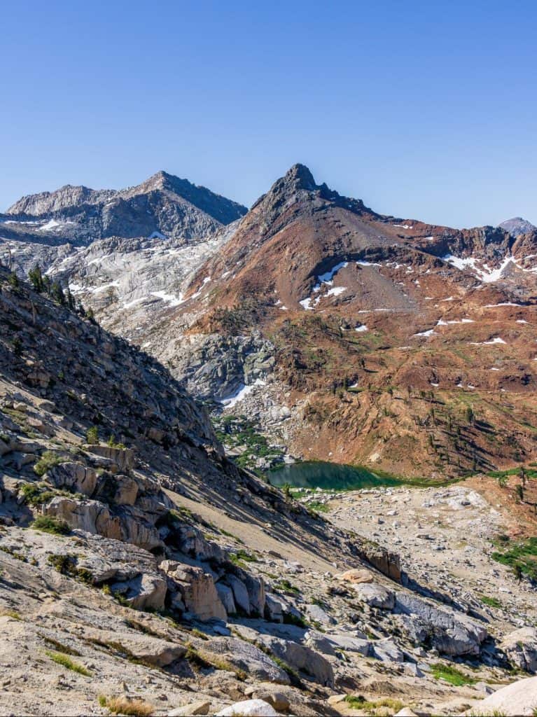
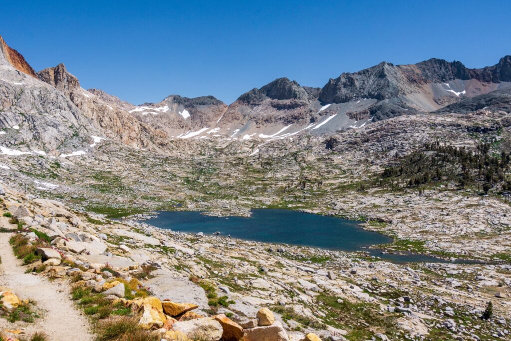
Lakes Trail to Pear Lake
This is another hike on my bucket list. I’ve been waiting for the perfect time to backpack camp here, but you can also do this trail as a long day hike!
The trail climbs up into the peaks overlooking the Giant Forest and winds by the most gorgeous alpine lakes. This all-day hike is for experienced hikers who are ok with the elevation gain and altitude.
Trail Info
- Distance: 12.5 miles
- Elevation Gain/ Loss: 3,100 feet
- Trail Type: Out & Back (loop option)
- Difficulty: Hard
- Trailhead: Wolverton
- Check current conditions and download on AllTrails
Alta Peak
Like the Lakes Trail, I can’t wait to hike to the top of Alta Peak. I’ve hiked below Alta Peak on the High Sierra Trail, but I just know that the view up there will be even more incredible!
Alta Peak is an all-day hike with thousands of feet of elevation gain, and should only be attempted during the summer months when the trail is free of snow.
Trail Info
- Distance: 13.8 miles
- Elevation Gain/ Loss: 4,000 feet
- Trail Type: Out & Back
- Difficulty: Strenuous
- Trailhead: Wolverton
- Check current conditions and download on AllTrails
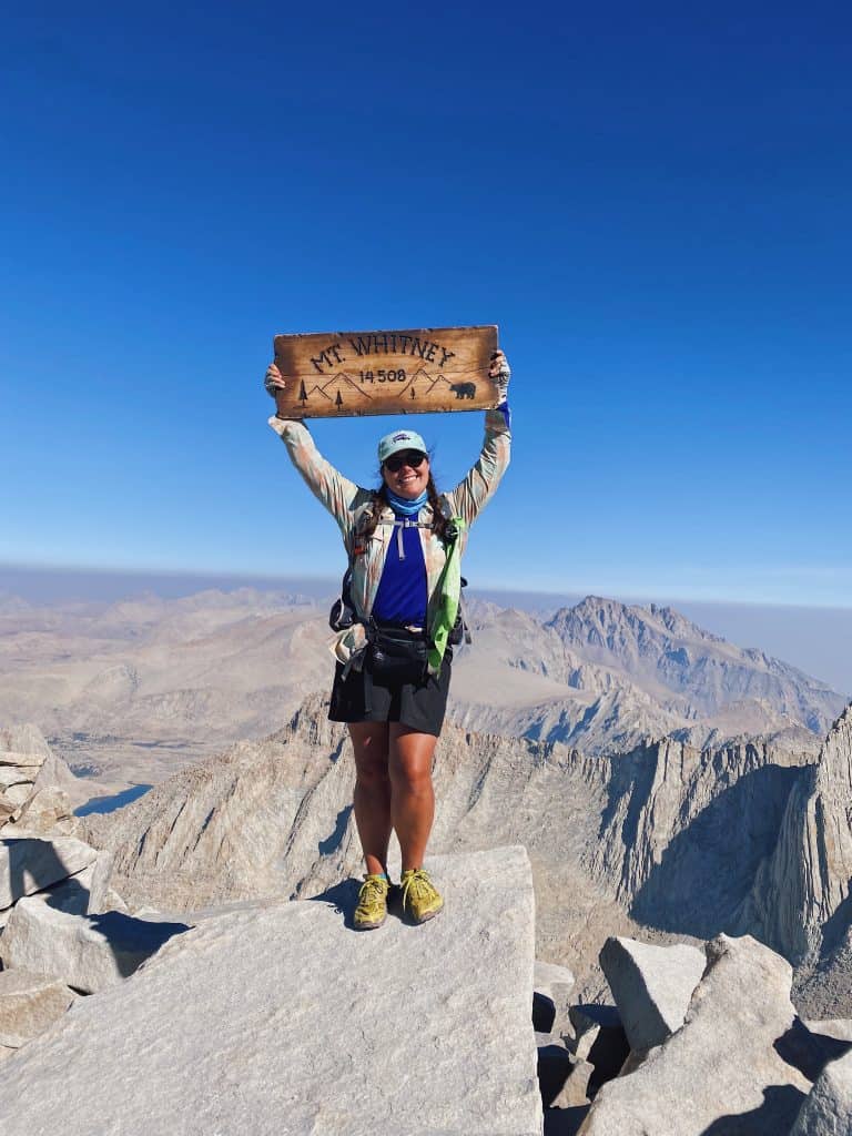
Mt. Whitney
I’ve summited Mt. Whitney 4 times now, and can confidently say that this hike is a beast, but if you want to stand at the tallest point in the lower 48 United States, you’ve got to attempt it!
The trail to Mt. Whitney as a day hike actually starts in Inyo National Forest on the eastern side of the mountain, and crosses the border into Sequoia National Park at Trail Crest, about 2.5 miles from the summit.
If you thought the Lakes Trail or Alta Peak sounded hard, I guarantee you that Mt. Whitney is more challenging. 22 miles and over 6,600 feet of elevation gain round trip on this hike – but the reward is amazing.
You will need to apply for permits to hike Mt. Whitney. The lottery is open every February for the following summer.
Trail Info
- Distance: 22 miles
- Elevation Gain/ Loss: 6,650 feet
- Trail Type: Out & Back
- Difficulty: Strenuous
- Trailhead: Whitney Portal, Lone Pine
- Check current conditions and download on AllTrails
Best Overnight Backpacking Trips in Sequoia
High Sierra Trail
The High Sierra Trail is a 72 mile backpacking trip that begins at Crescent Meadow, climbs over the Great Western Divide, and ends at the top of Mt. Whitney. Most people do it in 6-8 days, and it exemplifies the best of Sequoia National Park. You literally hike from the Sequoias to Mt. Whitney!
I backpacked the HST with my mom in 2019 and had such an amazing time. Precipice Lake and Kaweah Gap were two of my favorite sights on day 3 of our trip.
Trail Info
- Distance: 72 miles
- Elevation Gain/ Loss: 15,800 feet
- Trail Type: Point-to-point
- Difficulty: Strenuous
- Trailhead: Crescent Meadow
- Check current conditions and download on AllTrails

5 Lakes Loop in Mineral King
This is another amazing backpacking trip that brings you to some of the most beautiful alpine lakes, meadows, and passes in the whole world. Even after hiking the HST and JMT, I was blown away by how much beauty there was along this trail, and think it’s a must-do if you love the Sierra.
I hiked this loop with a friend in 2020 and I think it might be prettier than the High Sierra Trail – but the climbing is no joke. We were exhausted every day.
Trail Info
- Distance: 30 miles
- Elevation Gain/ Loss: 10,000 feet
- Trail Type: Loop
- Difficulty: Strenuous
- Trailhead: Timber Gap, Mineral King
- Check current conditions and download on AllTrails

John Muir Trail Section Hike: Onion Valley to Whitney Portal
This section of the John Muir Trail is one of the most iconic of the entire 211-mile trail, because it passes over Forester Pass, the highest maintained mountain pass in the Sierra Nevada, the high point of the entire 2,650-mile Pacific Crest Trail, and the official border between Kings Canyon and Sequoia National Parks.
You’ll start and end in Inyo National Forest on the eastern slopes of the Sierra, and climb into Kings Canyon National Park at Kearsarge Pass before hiking down to Vidette Meadow, a really stunning area along Bubb’s Creek. You’ll then climb up to Forester Pass, which is where you enter Sequoia, before traveling along Bighorn Plateau and into the Whitney Zone.
Because this is part of a popular trail, you’re likely to get help with hitchhiking and shuttles so you can do this as a one-way hike.
Trail Info
- Distance: 50 miles
- Elevation Gain/ Loss: 11,860 feet
- Trail Type: Point-to-point
- Difficulty: Strenuous
- Trailhead: Onion Valley, Independence
- Check current conditions and download on AllTrails
Best Time to Hike in Sequoia: Seasons & Weather
Sequoia National Park ranges in elevation from 1,000 feet above sea level to 14,505 feet above sea level! So in every season, the weather is going to vary drastically throughout the park. And even in the winter months, it could be snowing in the Giant Forest and only raining in the Foothills – I experienced this during my March visit.
The spring is where trail conditions vary drastically based on the winter snowpack, daytime temperatures, and how much shade exists in certain areas. I love using the trail conditions page that the park maintains to see what to expect when hiking each trail!
Summer is the best time of the year for hiking in Sequoia. You should expect relatively warm temperatures. It’s usually too hot in the Foothills for comfortable hiking weather, but the Giant Forest area, Mineral King, and the alpine will be nice. You might also see wild lupine in the Giant Forest in mid-summer, a treat for wildflower lovers!
Summer can see afternoon thunderstorms though – an important consideration to keep in mind especially if you are hiking in the alpine above the treeline – you won’t want to be exposed if lightning strikes! Make sure you start mountain climbs early in the morning to avoid getting caught in an afternoon thunderstorm. They don’t happen daily like in the Rockies, but they’re a possibility.

What to Pack For Hiking in Sequoia
You should always carry the 10 essentials in case something happens and to be safe. But there are a few other items that will make your experience a lot better on Sequoia’s trails. If you’re new to hiking or not sure what the 10 essentials are, check out my hiking basics guide!
Sweat Wicking Hiking Clothing
You’ll definitely work up a sweat hiking in Sequoia—especially doing some of the tougher hikes in the summer. I’ve been loving this breathable sun hoodie and these super breathable pants for max sun protection.
Supportive Shoes
I’m a die-hard trail runner girl, so you’ll find me in Altra Lone Peaks most of the time. Head to REI to get fitted for a hiking shoe or boot that works best for your feet. I wouldn’t recommend regular sneakers—many trails in Sequoia are rocky, dusty, or uneven, and you’ll want something with solid traction and support.
Warm & Dry Layers
Weather can change quickly in Sequoia, especially at higher elevations. Even in summer, mornings can be chilly and afternoon storms aren’t uncommon. I always recommend bringing a lightweight puffy or fleece, plus a rain jacket or poncho.
Water Filter
If you’re doing longer hikes in Sequoia—especially in the backcountry or away from developed areas—bringing a water filter is a smart move so you can refill from lakes or streams if needed. The Sawyer Squeeze is part of my 10 essentials and is always with me on hikes.
Backpack
You don’t need a huge pack, but having something comfortable that can carry the 10 essentials, water, and food for the day is key. I’d recommend getting fitted for a day pack at REI. This is the day pack I usually use.
Trekking Poles
These are super helpful for Sequoia’s longer trails. They provide stability, take pressure off your knees, and are especially nice if you’re tackling hikes with elevation gain or uneven terrain. You might not need them if you’re sticking to the easier trails! These poles are great for most hikers.

Top Tips for Hiking in Sequoia National Park
Leave No Trace
Adhering to the 7 principles of Leave No Trace ensures that we keep our wild spaces healthy and beautiful, and keep a good wilderness experience for the land and fellow hikers. Doing things like staying on the designated trails, not littering, not playing music out loud, and adhering to fire restrictions, are all examples of “leaving no trace”.
Remember that in areas where there are fences around sequoia trees, you should NOT climb over the fences to get closer to the trees. There are plenty of hikes in the park where there are not fences around the trees – do these hikes if you want to hug a tree.
The 7 principles are:
- Plan Ahead and Prepare
- Travel and Camp on Durable Surfaces
- Dispose of Waste Properly
- Leave What You Find
- Minimize Campfire Impacts
- Respect Wildlife
- Be Considerate of Other Visitors
Altitude
The most popular hikes in Sequoia all begin at around 6,800 feet above sea level, which is where some people can start feeling the effects of altitude. Breathing might feel more difficult even on slight uphills that you usually hike easily at lower altitudes!
You’ll want to keep this in mind, especially if your hikes are taking you above 9,000 feet. Staying hydrated is really important, and I’d make sure you’re carrying electrolytes and brush up on what altitude sickness can look like (shortness of breath, fatigue, and nausea are the most common early signs).
Wildlife
There’s lots of wildlife in Sequoia National Park – tons of birds, mule deer, rattlesnakes, bobcats, mountain lions, and black bears. Most people are worried about mountain lions and black bears.
The most important thing to keep in mind if you come across a large wild animal is to stay calm. It’s most likely going to run away from you, so enjoy the moment and the animal sighting – you were lucky!
If a large animal doesn’t run away, don’t run away. Make yourself look big and tall, protect small children, yell and wave your arms, don’t look them directly in the eye, and back away slowly. You can throw sticks and stones at an animal that doesn’t back off with yelling. Bear spray is prohibited in Sequoia National Park, and you usually won’t need it with black bears anyways.
Remember that these are wild animals. Never approach, touch, or feed them – even the small ones like birds and squirrels, and make sure you don’t accidentally feed them – keep wrappers and snacks in zipped backpack pockets, and use the bear lockers in parking lots to store your scented items if you’re backpacking or going on long day hikes (bears can destroy cars if they want something yummy smelling inside).
Parking, Trailheads, and Shuttles
There are a few main parking lots in the Giant Forest area of Sequoia where you’ll want to park and then take the free park shuttle to trailheads. You don’t have to take the shuttle to trailheads – most trailheads have parking associated with them, but on busy summer days, you’ll probably just want to park and not worry about trying to find a parking space at the next spot.
Plus, in the summer, the Crescent Meadow Road that takes you to hikes like Moro Rock, is closed during certain hours of the day, so you’ll need to take the shuttle to those trailheads. The parking lots at these trailheads are also very small. I think the Moro Rock trailhead only has about 20 spaces.
If you’re not visiting in the summer, the shuttle system won’t be running (except on certain winter holiday weekends). It’s much easier to find parking in the off season, so this won’t be an issue, but the General Sherman Tree and Lodgepole Parking Lots will be closed in the middle of winter.
The main parking lots are:
- Giant Forest Museum Parking Lot
- General Sherman Tree Parking Lot
- Wolverton Parking Lot
- Lodgepole Parking Lot
Hiking Permits
You don’t need any permit for day hiking in Sequoia, luckily (except for Mt. Whitney)! However, if you do want to go overnight backpacking, you will need to get a permit. You can reserve them 6 months in advance (to the day) or do a day-before walk-up permit at the Lodgepole Visitor Center.
Pets on the Trail
Pets are not allowed on any hiking trails in Sequoia National Park – even to the General Sherman. If you want to take a picture or see sequoia trees with your dog, the Sentinel Tree outside of the Giant Forest Museum is on a paved path and dogs are allowed there.
What About Hiking in Kings Canyon?
Kings Canyon National Park is right next to Sequoia and has its own host of hiking trails. I wanted to split these locations so I could properly do them justice, because I think Kings Canyon deserves its own day to explore. I’ve pulled some of the best ones in this guide to visiting both parks at once.

Plan Your Perfect Sequoia Trip
No matter how much time you have, Sequoia National Park has a hike that will completely blow you away — whether that’s standing beneath the giant General Sherman Tree for the first time or pushing yourself on a full-day alpine hike like Alta Peak.
And remember: Sequoia National Park has no cell service. There’s WiFi at the Lodgepole Market though, so make sure you download your trails and maps ahead of time. I like to use AllTrails Plus for ease!
If you’re still planning your trip, these guides will help you make the most of your time:
- How to Visit Sequoia National Park – everything you need to know about when to go, where to stay, and how to get around.
- Best Things to Do in Sequoia National Park – more ideas beyond hiking, including scenic viewpoints and must-see spots.
- Sequoia Day Trip Itinerary – what to see and do with only 1 day in the park.
- How to Spent 3 Perfect Days Hiking in Sequoia-Kings Canyon – a 3-day itinerary between the 2 parks with at least 1 major hike each day.